


GIS for telecommunications: Enterprise network management


June 16, 2026 11 min read 7 views
The traditional methods of tracking telecom infrastructure, such as using static maps and scattered spreadsheets, no longer provide adequate coverage. Networks are becoming increasingly dynamic as telecom operators expand their fiber and 5G footprints or continue to offer more distributed services. Avenga’s telecom engineering team helps operators move from static infrastructure records to live, data-driven network management. Therefore, telecoms require an accurate and timely representation of the infrastructure that exists, where it is located, and how well it is functioning; this is known as an enterprise GIS for telecoms.
A GIS for telecom combines asset data, spatial context, and real-time updates, so that infrastructure is more than just a series of isolated entries; it provides a working system of record. By leveraging more robust location intelligence systems and telecommunications GIS data, teams can operate networks more efficiently, make more informed decisions about network operations, and support every major business function that relies on the network’s reliability day in and day out.
GIS for telecommunications key takeaways
- Enterprise GIS gives telecom teams a clearer, location-based view of assets, operations, and network conditions.
- It supports planning, field coordination, maintenance, and disaster recovery across multiple telecom business areas.
- Digital twins build on GIS by creating a more active, living model of network infrastructure.
- As telecom networks grow more complex, GIS becomes less of a support tool and more of an operational system for smarter decisions.
The role of GIS in modern network planning
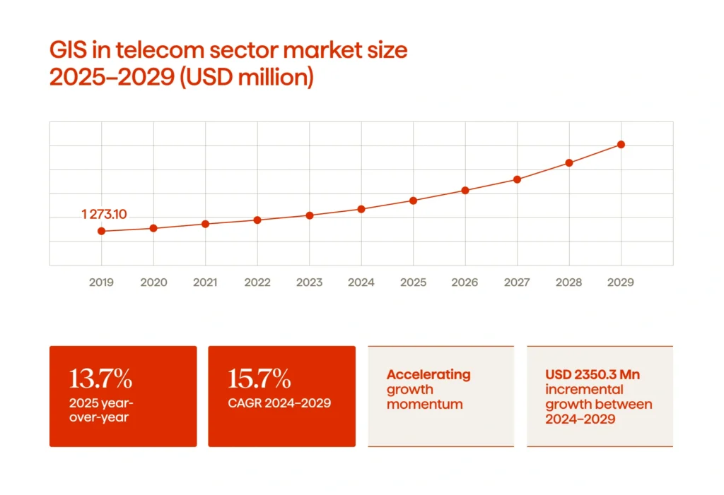
GIS has recently been positioned centrally within telco systems for two reasons: first, Technavio studies indicate that GIS growth in the telecom sector will reach USD 2.35B from 2024 to 2029, with an annual growth rate (CAGR) of 15.7%. Second, the increased usage of GIS for capacity planning is a primary factor for this increase.
This makes perfect sense. Along with coverage maps and asset inventories, planning within the telecom industry has evolved. Teams now need complete visibility into how physical infrastructure, demand, outages, permitting, and growth priorities all interact with each other, from a single operational view. GIS accomplishes this by converting spatial data about these elements into an operational resource for business decision-making within an enterprise. Using the appropriate GIS software, operators can map fiber routes, towers, ducts, field assets, service availability, and constraints within a single model.
Once GIS tools have provided the necessary information, the GIS will be used to support network planning in practice. Teams will have the tools they need to evaluate existing network capacity, identify where upgrades are needed, and manage overall network growth, rather than having limited visibility into where to make infrastructure decisions.
For communications service providers, these infrastructure decisions will have a direct impact on three major things: the ability to provide service to their customers, customer experience, and cost. In summary, GIS supports a variety of core business functions (planning, operations, resiliency, and, ultimately, achieving more sustainable revenue growth).
What are digital twins?
A digital twin is a real-time digital representation of a tangible asset, system, or environment, applied in the telecommunications industry to show how towers, fiber-optic lines, cabinets, power systems, coverage zones, and other infrastructure exist, using connected telecommunications GIS data, operational inputs, and asset records. Within telecommunications enterprise GIS, this model is more than just a simple map. It allows teams to see the existing infrastructure in the field, understand how it is changing, and identify potential issues to address.
Why telecoms are adopting them
Telecom networks are harder to run with static records alone. First, network assets are distributed over a vast area; second, user demand for services within that area is rapidly changing; and third, field personnel and office staff need to share a common view of the network. A digital twin combines geographical information, current asset information, and general data management standards to provide a single environment for managing digital network operations.
Teams use this model to manage multiple individual reference tools (location, history, and operational context) into a single shared system that provides a more accurate representation of the network. The value of your telco project usually derives from improved planning efficiency, better coordination among departments, and a more effective use of location for daily decision-making.
How they differ from traditional GIS
Telco firms typically use standard GIS systems to archive, view, and analyze location-relational network data (spatial network data). While these systems do fit this description and are needed, most function primarily as robust record systems. Conversely, a digital twin builds upon telecommunications’ enterprise GIS solution by adding an operational, value-added layer of data; this often includes design data, real-time information, maintenance information (historical and real-time), and performance/behavior information for assets or location-related activities.
The distinction is not between GIS and digital twin; it’s between the two in terms of activity and depth. GIS (including platforms like ESRI) provides spatial data, while digital twins leverage GIS data to provide a more powerful means to model composite activity across a network over time.
Avenga’s telecom experts will manage your existing infrastructure, ensuring seamless operations while migrating your resources to a scalable architecture, data-driven frameworks, and automated processes.
Key applications in telecom infrastructure
When telecom GIS is linked to everyday network activity, it confirms its value as more than just a mapping layer; it’s an organizational tool for providing information about all the assets, context, and activities associated with a single operational view of those assets. Teams can use accurate GIS data to support business decisions that affect service quality and uptime by managing activities to improve expansion plans and serving as a bridge between office and field workflows.
Network planning
Telecom network design involves much more than simply plotting lines on a map. Designers have to consider many factors, including coverage gaps, terrain, available permits, existing assets, service demand, and future capacity. GIS telecom tools are instrumental in this process because they provide planners with contextual geospatial information that is integrated with their database of network records, so that when they begin planning new infrastructure, they have the information needed to make informed decisions regarding where to expand infrastructure and the potential for constraints that may impact deployment, how various scenarios for expansion may affect cost and performance, etc.
Avenga works with telecom operators across the full infrastructure stack, from OSS/BSS modernization to field operations software. Learn more about Avenga’s telecom engineering services and how we support network-level decision-making.
Field operations
Accurate crew coordination, dispatch, and support for teams, engineers, and staff are critical to successful operations. When communication about the hand-off from the field to the office is lacking, this can lead to delays in repairs, duplication of work, or the use of outdated information. Using a GIS system that provides both sides access to the same spatial representation of the network will reduce this risk.
Within the field of telecom GIS operations, the technician will be able to locate assets quickly, confirm the presence of co-located infrastructure, review historical records, and update their records, which will also benefit the next technician supporting them. In the end, there will be decreased back-and-forth communication, providing better control over operational workflows.
Predictive maintenance
Effective maintenance occurs when teams can detect patterns before a failure becomes an outage. Using telecommunications GIS, asset locations, maintenance histories, environmental exposures, and incidents can all be linked together. With this information, operators can identify which parts of their networks should receive early attention.
GIS has another less obvious strength: it allows teams to shift away from reactive repairs and to develop more informed maintenance plans. Over time, with GIS, operators will create a more stable network by enabling them to establish inspection priorities, reduce unavoidable maintenance interruptions, and provide better context for managing critical infrastructure.
GIS solutions: Future trends
GIS is evolving from a focus on asset mapping to a fully connected operational platform that enables the planning, maintenance, rollout, and coordination of services across many areas of the telecom business. For many telecoms, GIS will now function as an enterprise-wide business application, providing a complete network view rather than a separate application or tool used by specific teams.
For networks that extend beyond terrestrial infrastructure, GIS principles apply equally to satellite operations. See how satellite technology is evolving in 2025 and beyond and what that means for network management.
Integration of IoT with GIS
A significant shift involves the growing importance of integrating IoT devices with geographic information systems. By providing live operational signals from each network asset, GIS enables their spatial visualization, making them easier to interpret. For telco teams, this means sensor inputs, equipment statuses, and field conditions can now be linked to the physical network rather than treated as individual events. This provides a more complete picture of the operating environment when monitoring and responding to issues.
AI’s role extends well beyond GIS, from predictive network maintenance to real-time traffic management, explore how AI is reshaping the entire telecom industry at the infrastructure level.
Cloud-Based GIS Solutions
The deployment of GIS is also being transformed by cloud delivery. This is important because telecoms do not exist in a single location (office) and/or on a single stack (platform). Cloud-based GIS will allow multiple teams spread out across the organization to use the same system while providing fast updates and the ability to extend solutions in the field and the back office.
Advancements in 3D GIS and digital twins
There’s also a continuing trend toward 3D GIS and geospatial digital twins. In fact, a digital twin is a virtual representation of reality using geographic information. Esri notes that GIS-based twin models include time and are not simply visual, which is an important factor for telcos, as networks continually change. A more complete 3D, time-based model will assist teams in understanding how assets are related, visualizing above and below-ground infrastructure, and making operational decisions with additional depth of context.
Growth of location intelligence
Location intelligence for telecommunications is a trend increasingly driving decision-making. The data that underpins the understanding of mobile assets, mobile workflows, and next-gen networks is called Location Intelligence (LI). In practical terms, LI assists telecommunications companies in determining which upgrades to prioritize, identifying service gaps, and aligning technical solutions with commercial priorities across various telecom lines of business.
Open data and interoperability
As telecom ecosystems become increasingly complicated, Open data & Interoperability will continue to increase in importance. OGC standards were designed to enable seamless transfer of geospatial data between dissimilar systems. Today, the OGC supports newer web APIs using current development methodologies (e.g., JSON, REST, and OpenAPI). This will improve integration with OSS, BSS, and other operational systems by reducing the number of closed geospatial data silos in GIS systems and favoring more open ones.
GIS does not operate in isolation, for full operational intelligence, it needs to connect with OSS and BSS platforms. Read Avenga’s deep dive on the future of OSS/BSS in modern telco to understand how those integrations work in practice.
FAQ
The future of next-generation network initiatives
An enterprise GIS is no longer just a multitude of layers in a map. With all the moving parts of an enterprise, enterprise GIS is also a dynamic platform for managing a network. As infrastructure, operations, and location-based insight are integrated into a cohesive body, telecoms no longer work from little pieces but instead have a much clearer view of the whole.
This change matters. It turns fragmented assets into a cohesive, readable system, accelerates asset recovery capabilities, and adds a layer of context to each decision. In a business built on people’s connections, visibility provides a competitive advantage in itself.
See how Avenga has delivered network engineering and modernization for global telecom operators across infrastructure, OSS/BSS, and product development: explore Avenga’s telecom case studies.
If you want to learn more about geospatial awareness and intelligent decision-making? Contact Avenga, your trusted technology partner.


Your business results matter
Achieve them with minimized risk through our bespoke innovation capabilities. Fill in the form below.